It’ll bring a few downpours to San Antonio by tomorrow
FORECAST HIGHLIGHTS
-
TROPICAL SYSTEM IN GULF: May briefly reach depression status
-
RAIN CHANCES: Scattered activity overnight, early on Saturday in SA
-
FLOODING NOT EXPECTED: Isolated 1″+possible, but most will see less than 0.50″
FORECAST
Hurricane hunters have been investigating the system in the Gulf and while it is showing signs of organization, it’s quickly running out of time. It may briefly reach depression status before moving ashore later today.
WHAT DOES IT MEAN FOR US?
Scattered rain will initially affect the Rio Grande Valley. By this evening, however, some of that moisture will begin to spread north towards San Antonio.
-
Our best rain chances will be overnight Friday through early Saturday afternoon.
-
Most of us will see less than 0.50″, however a lucky few may get a heavier downpour, allowing for 1″+. On the flip side, some of us will see nothing at all. Any flooding, if we see any at all, would be very isolated.
-
It will not bring steady rain, only spotty downpours (40%), so keep your Friday night and Saturday daytime plans.
DRY & HOT SUNDAY
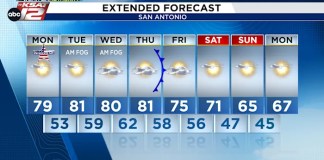
Drier conditions will take over on Sunday. After a minor break from triple digit heat, 100s return by Sunday afternoon, with mostly sunny skies.
RAIN NEXT WEEK
An active pattern makes a return by the middle of next week. Rain chances look to return, especially by Thursday and Friday. This should help to drag temperatures down. Stay tuned for updated rain chances as we get closer.
QUICK WEATHER LINKS
Copyright 2025 by KSAT – All rights reserved.
About the Author
Great Job Justin Horne & the Team @ KSAT San Antonio Source link for sharing this story.


